Outdoor Adventure
Your Complete Guide to Arizona's National Wildlife Refuges
Arizona is home to nine national wildlife refuges, all of which are located in the southern region of the state. These refuges provide habitat for a wide range of species in the desert, and they offer visitors recreational opportunities like hiking, camping and even boating.
Buenos Aires National Wildlife Refuge (Sasabe, Arizona)

A long-eared owl strikes a pose in Buenos Aires National Wildlife Refuge. All photos by Elisabeth Brentano.
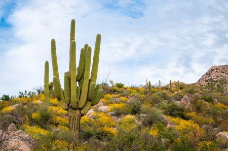
Buenos Aires National Wildlife Refuge was purchased by U.S. Fish and Wildlife Services in 1985 to provide critical habitat for the endangered masked bobwhite quail. The 117,464-acre refuge, which was once a network of cattle ranches, is also home to hundreds of avian species, plus pronghorn, deer, javelina, coyotes, bobcats, mountain lions and possibly even jaguars. Located in the heart of the Sonoran Desert, Buenos Aires National Wildlife Refuge is a birder’s paradise, and the views of the Baboquivari Mountains (lead image) are absolutely breathtaking.
The refuge has a handful of short hiking trails, including the Aguirre Lake Trail, the Arivaca Creek Trail and the Arivaca Cienega Trails, along with 83 numbered, dispersed campsites. The aptly-named Pronghorn Loop Drive is your best chance to see the resident pronghorn herd, and the Visitor Center is home to a flight pen with captive masked bobwhite quail. While the refuge has a reintroduction program for the birds, these quail are not candidates for release in the wild. The Visitor Center has an information center and a garden, along with blinds and benches. The refuge sits along five and a half miles of the U.S.-Mexico border, so visitors may encounter border patrol agents in the area. The closest towns with services are Arivaca (a 30-minute drive northeast of the Visitor Center) and Three Points (a 45-minute drive north of the Visitor Center).
Cibola National Wildlife Refuge (Cibola, Arizona)

A group of sandhill cranes fly past the Trigo Mountains in Cibola National Wildlife Refuge.
Cibola National Wildlife Refuge was established in 1964 to help protect and recreate the Colorado River’s marshes and backwaters, which existed before channelization in the 1960s. Over 280 avian species have been recorded at the 18,444-acre refuge; the most common sightings include sandhill cranes and snow geese, plus a variety of ducks and raptors. Visitors may also spot coyotes, mule deer and bobcats.
The Goose Loop auto tour, which is approximately three miles long, begins several hundred feet from the Visitor Center, and this gravel road offers views of the Long Pond and Arizona’s Trigo Mountains. The pullout near the Long Pond has room for several cars, so it’s the perfect spot to roll down the windows and observe the birds. The one-mile Cornfield Nature Trail is located on the Goose Loop, and in addition to benches and an observation platform on the trail, there is a pit toilet at the trailhead. With the exception of the Cornfield Nature Trail, visitors must stay inside their vehicles along the Goose Loop auto tour route. Visitors can also explore Cibola Lake, which is located nine miles south of the Visitor Center, via the eastern levee road. The closest town with services is Blythe, California, which is a 30-minute drive north of the refuge.
Kofa National Wildlife Refuge (Yuma, Arizona)

Sunset in Kofa National Wildlife Refuge captured near Palm Canyon Road.
Kofa National Wildlife Refuge was established in 1939 to protect desert bighorn sheep, and over 80 percent of the 547,719-acre refuge is designated as wilderness. Even if you don’t spot any bighorn, the landscape alone makes this refuge well worth a visit. The jagged spires of the Kofa Mountains rise from a sea of saguaros and ocotillos, and the Castle Dome Mountains to the south boast equally impressive features.
The most popular hike is the Palm Canyon Trail, which is located off Palm Canyon Road, a wide and well-maintained dirt road. The trail is easy to follow for the first half mile, but after passing the sign for the palms in the canyon, it becomes a bit of a scramble. The refuge is also open to dispersed car camping for up to 14 days. Visitors must keep their vehicles within 100 feet of the centerline of designated roads, and campsites must be a quarter of a mile from water sources. The refuge sits along State Route 95, between Yuma and Quartzsite, both of which are 45-60 minutes away, depending on where you are in the refuge.
Imperial National Wildlife Refuge (Yuma, Arizona)

A great blue heron at the Palo Verde observation point in Imperial National Wildlife Refuge.
Imperial National Wildlife Refuge was established in 1941 to protect wetland habitat for migratory birds along the lower Colorado River. The 25,768-acre refuge sits along the Arizona-California border, and this is the last un-channelized section of the river before it crosses into Mexico. 275 species of birds have been observed at the refuge, and visitors may also spot coyotes, bighorn sheep and wild burros.
After stopping by the Visitor Center, follow Red Cloud Mine Road north to access the Palo Verde, Mesquite, Ironwood and Smoke Tree observation points, all of which offer views of the wetlands around the Colorado River. The trailhead for the Painted Desert Trail is a quarter of a mile before the turnoff for the Ironwood vista, and the 1.3-mile loop offers views of the Colorado River valley and rainbow-hued rock formations. Another option is the Meers Point Trail, a .8-mile point-to-point route that meanders from the Visitor Center south to Meers Point, which can also be accessed by vehicle. Meers Point Recreation Area has a boat ramp, benches, shade structures, toilets and two viewing docks overlooking Martinez Lake. The closest town with services is Yuma, which is a 50-minute drive south of the refuge.
Cabeza Prieta National Wildlife Refuge (Ajo, Arizona)

Views on the east side of Cabeza Prieta National Wildlife Refuge, near the town of Ajo.
After being established as a game range in 1939, Cabeza Prieta became a national wildlife refuge in 1975. The 860,010-acre refuge, which is the third largest in the lower 48 states, provides habitat for desert bighorn sheep and endangered Sonoran pronghorn, plus a number of reptiles and small mammals.
On the second Saturday of each month, the refuge offers tours and allows visitors to drive to Childs Mountain for sunset. Outside of the tours, the road is closed to the public, but visitors may park by the locked gate and hike to the summit if they obtain a permit from the Luke Air Force Base. The hike is approximately eight miles round trip with 1,200 feet of gain. For visitors wishing to explore the refuge by vehicle, Charlie Bell Road is the best option. A high-clearance vehicle is recommended, and it’s best to call the Visitor Center and ask about current road conditions.
Dispersed car camping is allowed in the refuge for 14 days within a 28-day period. Visitors must keep their vehicles within 50 feet of the centerline of designated roads, and campsites must be a quarter of a mile from water sources. There are also three developed campgrounds: Papago Well, Tule Well and Christmas Pass, all of which are located on El Camino del Diablo Road. Permits, along with a high-clearance, 4x4 vehicle are required to travel along El Camino del Diablo and Christmas Pass, and visitors should carry at least one spare tire, recovery gear, and extra water. The refuge sits along 56 miles of the U.S.-Mexico border, so visitors may encounter border patrol agents in the area. The closest town with services is Ajo, which is less than an hour from most points in the refuge.
Bill William River National Wildlife Refuge (Lake Havasu City, Arizona)

The Bill Williams River, as seen from the entry to Planet Ranch Road.
Once part of Havasu National Wildlife Refuge, Bill Williams River National Wildlife Refuge was established as a separate 6,100-acre unit in 1993. The refuge helps protect migratory birds and other wildlife, and the ecosystem serves as a transition zone between the Sonoran and Mojave Deserts. In addition to a number of observation decks at the Visitor Center, the one-mile Peninsula Trail offers several more observation decks and fishing piers along the Bill Williams River. The half-mile Delta Loop Trail also starts at the Visitor Center, running in the opposite direction. Additional trails (Valley View, Slot Canyon, Red Bluffs, Riparian Overlook and Mineral Wash) are located on Planet Ranch Road. The dirt and gravel road is half a mile north of the Visitor Center, on the opposite side of Arizona State Route 95. The road can get washed out and rutted, so it’s best to call in ahead of your trip and check current conditions. The closest towns with services are Parker (a 30-minute drive south of the refuge), and Lake Havasu City (a 40-minute drive north of the refuge).
Leslie Canyon National Wildlife Refuge (Douglas, Arizona)

A mourning dove perches on an ocotillo in Leslie Canyon National Wildlife Refuge.
Leslie Canyon National Wildlife Refuge was established in 1988 to protect the Yaqui chub and topminnow, two of the eight native fish species in the Yaqui River watershed. While the drive in from Highway 191 via Davis Road is about 11 miles, the stretch of Leslie Canyon Road that cuts through the 2,765-acre refuge is only a mile and a half long. The road is wide, gravel and well-maintained, and a 4x4 vehicle is not necessary. The Leslie Canyon Trail, which is the only trail in the refuge, is mostly flat and approximately two miles roundtrip, with a designated parking area for a few vehicles. The closest town with services is Douglas, which is a 35-minute drive south of the refuge.
San Bernardino National Wildlife Refuge (Douglas, Arizona)

Views from Geronimo Road, which provides access to San Bernardino National Wildlife Refuge.
San Bernardino National Wildlife Refuge was established in 1982 to protect native fish in the Yaqui watershed, along with a number of avian species. At 2,369 acres, this is Arizona’s smallest national wildlife refuge, and it is only accessible by foot traffic. The refuge is home to a small network of trails located off Geronimo Road, which runs along the western and northern borders of the refuge. The main trail, a former access road (still listed as San Bernardino Game Refuge Road on some maps), is wide and flat, but trails leading to the ponds are not regularly maintained, and they are often overgrown. In addition to being mindful of snakes in the vegetation, an increase in Africanized (killer) bee activity has been reported in the area, so visitors should use caution when exploring on foot. For those who would rather stay in a vehicle, Geronimo Road, which is mostly gravel and well-maintained, offers amazing views of the landscape. The refuge sits along two and a half miles of the U.S.-Mexico border, so visitors may encounter border patrol agents in the area. The closest town with services is Douglas, which is a 30-minute drive west of the refuge.
Havasu National Wildlife Refuge (Lake Havasu City, Arizona)

The Colorado River curves around the Needles Mountains in Havasu National Wildlife Refuge.
Havasu National Wildlife Refuge, formerly Havasu Lake National Wildlife Refuge, was established in 1941 to provide habitat for migratory birds. The 37,515-acre refuge is within the Pacific Flyway, a major migratory route for birds, and it is also considered an Important Bird Area in Arizona. While the Visitor Center is located across the state line in Needles, California, the majority of the vistas and trails are on the Arizona side. Mesquite Bay and Castle Rock are located in the southern region of the refuge off London Bridge Road, and both viewpoints have short nature trails. Catfish Paradise, which has a viewing dock and boat ramp, is located near Topock, off Interstate 40. North Dike and Five Mile Landing, which are off County Route 1, also offer boat access to Topock Marsh. The closest towns with services are Needles, California (a 20-minute drive northwest of the refuge), and Lake Havasu City (a 40-minute drive south of the refuge).