Arizona Trail
Gila River Canyons
The Arizona National Scenic Trail—known as the “AZT”—traverses the entire state. But you don’t have to tackle all 800 miles at once. This day hike near the Grand Canyon’s North Rim takes you to one of Arizona’s most spectacular fall-color scenes.
Arizona has a reputation for being a dry place, but along this hike, you’ll get to see a riparian environment along the Gila River with large trees and running water underneath a picturesque trestle bridge. You’ll also go past two Crested Saguaro, a rare mutation that creates a fan shape. This passage of the trail was the last to be completed and you’ll see the “Golden Spike” where it was connected from Mexico to Utah.
On the Trail
From the parking lot on Centurion Road, make a left at the first intersection toward a gate with an Arizona Trail emblem on it. The trail heads west on a closed roadbed, paralleling the Gila River and the Copper Basin Railway.
At 0.3 miles the AZT makes a right, away from the railroad tracks, to head north past a trail register. The trail curves right and climbs next to a wash. At 0.7 miles, cross the wash that you have been following and turn left to go south. Shortly afterward, the Gila River comes into view once again.
As you gain elevation, the open-pit Ray Mine comes into view to the northeast. This area has had mining claims since the 1870s and copper, silver, gold, lead, and zinc have been extracted.
Follow the trail as it climbs at a steady grade with one short downhill. At 1.8 miles, the Gila River comes back into view.
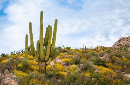
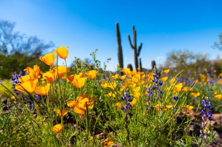
This area is great for both wildflower season in late February and March and Fall colors, which don’t occur at this low elevation until mid-December into early January. The cottonwoods in the riparian corridor turn it into a river of gold.
In 0.1 miles, the trail makes a turn to the west, paralleling the river but far above it. The trail reaches the high point of this hike at 2.25 miles and starts a series of switchbacks to descend.
Golden Spike
The completion marker, or “Golden Spike” of the Arizona Trail is at 2.3 miles. It was placed in a ceremony on December 16, 2011, connecting the AZT from Mexico to Utah. DS for Dale Shewalter, father of the Arizona Trail. The marker is close to the ground to the right and easy to miss.
Dale, a Flagstaff math teacher, hiked a route from Mexico to Utah in 1985, connecting public lands and bushwhacking through the desert when there was no trail. He was so inspired by his walk that he took the next year off to travel around to the various agencies to pitch his idea of a trail that would connect the diverse environments and small towns of Arizona. The Arizona Trail Association was formed in 1994 and thousands of volunteers worked for years to complete the trail. It gained National Scenic Trail (NST) designation in 2009 and is only the third NST to be completed out of 11. Dale passed away in 2010 but he leaves a legacy that will be enjoyed by generations to come.
There is a wonderful view from the completion marker of the trestle bridge, the S-curve of the Gila River, rugged saguaro-studded slopes, and the A-Diamond Ranch in the distance with a backdrop of the Tortilla Mountains.
From this point, you can turn back for a 4.6-mile hike with 350 feet of elevation gain. If you decide to continue to the trestle bridge, be aware that it is a 350-foot drop in elevation that you’ll need to regain on your way back.
The trail begins a series of switchbacks, every one of them bringing you closer to the river. Pass a rocky outcropping and curve into a small side canyon. There are short stretches where it is steep and gravelly.
At 2.75 miles, the first Crested Saguaro comes into view to your right (north). The best angle is just as the bridge comes back into view at 2 o’clock. Crested (aka Cristate) Saguaro are very rare and somewhat of a mystery. Scientists don’t know for certain what causes this mutation.
At mile 2.9, just after the trail switchbacks to follow the river toward the bridge again, the second crested Saguaro comes into view on the left (south) side. The trail goes right past this crest that has five small arms. It is just off the trail just as it makes a curve to the right.
At 3.0 miles, start the final descent with a view of the tracks, mesquite bosque and cottonwoods, and Saguaros below. The trail follows a fence line at the bottom of the descent. At 3.1 miles there is a turn-off to the left (south) to visit the trestle bridge.
Take a left on a well-worn path and go less than 0.1 miles to a view of the tracks and bridge. Please respect private property and Do Not Trespass signs and keep a safe distance. Do not ascend to the tracks. The river can also be accessed at this point.
Go back to the junction and take a right to go back the way you came for a total of 6.3 miles roundtrip. If you missed the completion marker on your way out, it’s just before you reach the high point on the left side of the trail.
When you’re done with the hike, head south to Kearny, “The friendliest Gateway Community on the Arizona Trail”. The owners of Old Time Pizza, Gary and Lorraine Birkett, have been feeding hungry hikers for many years and even do trailside pizza delivery to the Gila River bridge!
For more information on the 800-mile Arizona National Scenic Trail, visit aztrail.org
If You Go
Trailhead: Centurion Trailhead
Arizona Trail Passage: Gila River Canyons – Passage 16
Trailhead Elevation: 1,646-3,714 feet
Round-trip length: 6.3 miles to trestle bridge, 4.6 to Completion Marker
Why go: Gila River views, Crested Saguaro, Completion Marker, Wildflowers and Fall Colors
Nearest Gateway Communities: Kelvin/Riverside (no services), Kearny
Post-hike meal: Pizza and the “Best Iced Tea in Kearny” at Old Time Pizza
Author
Sirena Dufault is the author of the forthcoming book, “Day Hikes on the Arizona National Scenic Trail,” which will be published by Wilderness Press. For more information, visit trailsinspire.com.