Arizona Trail
American Flag Trailhead to Oracle Ridge
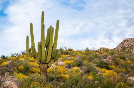
The Arizona National Scenic Trail—known as the “AZT”—traverses the entire state. But you don’t have to tackle all 800 miles at once. This dayhike visits two historic ranches on its way to a scenic ridgetop view.
This passage of the Arizona Trail (AZT), near the Gateway Community of Oracle in the foothills of the Catalina Mountains, goes through oak-studded grasslands, visiting two historic sites with expansive views of the San Pedro River Valley and Galiuro Mountains.
On the Trail
Right from the trailhead (4,408’), visit a piece of territorial Arizona history at the American Flag Ranch. The ranch house was built by Isaac Laurin in 1877 and was designated as the post office.
Take the AZT through the sign that says “The Arizona Trail” with a smaller sign that says “Santa Catalina Mountains Segment – Dedicated May 20, 1989”. The sign across the way that simply says “The Arizona Trail” is the AZT toward Oracle State Park. There is a sign to your left that says Cody Trail #9.
The trail curves to the left past the wooden corral and switchbacks up the grassy hill. As you gain elevation, views to the east open up toward the San Pedro River Valley and the Galiuro Mountains. In 0.3 miles, reach a small plateau and curve through the flats, then resume climbing.
Start the descent into a canyon at a switchback to the left. Looking east, the mountains in the distance are the Rincon Mountains. In 0.2 miles, the descent ends and the trail crosses a small sandy wash. The trail descends to parallel the wash briefly on its right side and follows it through red-barked manzanita and oak trees. The trail follows the left side of the wash, and makes a turn to the left in 0.2 miles to resume climbing away from the wash to the south. Cross beneath two sets of powerlines.
American Flag Hill
To your right (north) is American Flag Hill. The boulder formations for which Oracle is known for start to appear. Look to your right for a marker made of rocks that says “200” on the ground. This is the distance from the Southern terminus at the Mexican border. Climb to a dirt road, Wildcat Trail, in 0.4 miles.
**Look across the road and to your right (north) to see the continuation of the trail just beyond the dip in the road. Turn right and descend just past the bottom of the dip, when the road begins to climb take a look to your left (west) to continue on the AZT.
Switchbacks climb a low hill, and the trail crosses another set of powerlines, then a dirt road. The trail continues climbing to the west, with the last switchback in 0.4 miles. The trail makes a turn to the right ascending below a grassy ridge.
Enjoy the Flora
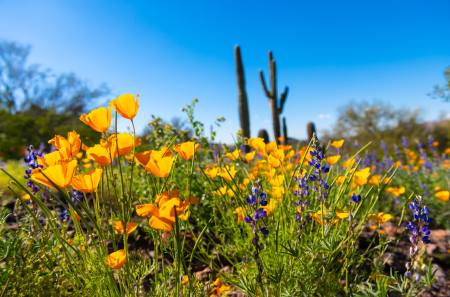
Pass large, serrated-leaved Sotol plants that may have gigantic stalks protruding from them. The plant sends up a stalk that can be as tall as 15 feet, which falls and then scatters seeds, perpetuating the plant. The non-serrated plants that look similar are Beargrass. Go through an area with large granite boulders.
*In 0.2 miles, the trail makes a turn to the right. Do not take the use path going straight. A brown Arizona Trail sign indicates the turn.
The trail curves to the left and the historic High Jinks Ranch can be seen across the canyon. There will be a turn-off for the ranch in 0.1 miles. Curve around the head of the canyon and reach a junction with a metal sign that says: “Arizona Trail - Utah 602/Mexico 199,” with a sign pointing to the High Jinks Ranch that says “Water - Camping - Lodging 500 feet”. This is the turnoff to visit the second historic site on this hike.
From the junction, take a left (southwest). the access trail makes a short climb and then goes through a portal that says High Jinks. There are two driveways in front of you: Oak Creek Ranch is to the right and the High Jinks Ranch is to the left. The sign says National Historic Site.
Reach the High Jinks sign, water spigot and sheds – and a gate with a sign saying “Ring bell - private residence”. This is the end of the short hike at 2.0 miles/ 650 feet of elevation gain (4,954’).
Buffalo Bill Cody and the High Jinks
In 1912, Buffalo Bill Cody came to Arizona to stake a gold mining claim he called the High Jinks Mine. His foster son, Johnny Baker, built the main house on the property in the 1920s, complete with a crow's nest third-floor bedroom with windows that give a view of more than 180 degrees. Over the years, more buildings were added to the property.
In 1975, Dean Prichard bought the ranch, spent years restoring it and turned it into living spaces and a common spot for parties. Dean was a founding member of the Arizona Trail Association, so when they were laying out the path that the Arizona Trail would take near Oracle, he routed it right past the High Jinks Ranch.
In the driveway of the ranch are historic parts of movie sets, including an 1895 Buckboard wagon that was used in the movie Poker Alice with Elizabeth Taylor. You’re welcome to water and views, but respect the signs for private property. If you’d like to see the historic house you can call ahead to schedule a tour. Overnight stays may also be available at the rustic casita, call 520 404-2874 or email info@highjinksranch.net for more information.
After Prichard's passing in 2007, the ranch lay vacant for many years. Astronomer Dan Blanco took over the ranch in 2011 and was responsible for restoring the ranch and setting up several of the buildings to accommodate Arizona Trail travelers. As of this writing, the ranch is currently for sale.
When you're done visiting High Jinks, cross the road. The portal that says “To the Arizona Trail” makes a great spot for a photo. For the shorter 4-mile version of this hike, at the junction make a right to go back the way you came.
Back to the AZT, go straight at the junction. The trail traverses through boulders, crosses a powerline, and in 0.3 miles the trail curves into a canyon and descends to cross it. Begin switchbacking up the grassy hill. The trail traverses another boulder-lined shady part of the trail and then continues climbing to the southwest past the Oak Creek Ranch.
In 0.3 miles, take a right into a small side canyon and continue climbing. Take a breather to enjoy great views of the boulders, Sotol and Beargrass, and San Pedro River Valley with the Galiuro Mountains to the east.
Continue climbing past some boulder formations and in 0.3 miles, cross the top of the ravine. The trail continues climbing and turns right. Head west and just before the junction, the trail turns south, reaching the Oracle Ridge Trail #1 junction and the highpoint of the hike at 3.4 miles (5,353’).
Off-Planet Colonization
As you crest the ridge, the futuristic domes of Biosphere 2 are visible in the valley, and the small pointy mountain in the distance to the northwest is Picacho Peak. Biosphere 2 was designed to develop technology for colonizing space by mimicking 7 different environments on Earth. There were two missions with eight “Biospherian” scientists each, one from 1991 - 1993 and one from March to September in 1994. It continues to be administered by the University of Arizona since 2011 and is open for tours daily.
Take a break to take it all in and then return to the trailhead the way you came, enjoying the expansive views of the San Pedro River Valley on your way down. On your return, make sure to take a right and join the road up to top of the hill and then take a left back onto the singletrack AZT at the point noted with an asterisk.
For more information on the 800-mile Arizona National Scenic Trail, visit aztrail.org
If you go
Trailhead: American Flag Trailhead
GPS coordinates: N32° 34.851' W110° 43.225'
Arizona Trail Passage: #12 Oracle Ridge
Trailhead Elevation: 4,408’
Round-trip length: 7 miles out and back to Oracle Ridge with side trip to High Jinks Ranch
Elevation gain/loss: 1077 ft.
Short version: 4 miles out and back to High Jinks Ranch - 650 feet elevation gain/loss
Difficulty: Moderate
Season: Winter, Spring, Fall
Why go: Historic ranches, scenic views, beautiful boulders and grasslands
Nearest Gateway Communities: Oracle - 4 miles
Author
Sirena Rana Dufault is the author of the forthcoming book, “Day Hikes on the Arizona National Scenic Trail,” which will be published by Wilderness Press. For more information, visit trailsinspire.com.