Arizona Trail
Gabe Zimmerman to Colossal Cave
The Arizona National Scenic Trail—known as the “AZT”—traverses the entire state. But you don’t have to tackle all 800 miles at once. This day hike near the Grand Canyon’s North Rim takes you to one of Arizona’s most spectacular fall-color scenes.
Cienega Creek is a special place east of Tucson with towering cottonwood trees, a seasonal stream and great views of the surrounding Rincon Mountains. The Arizona Trail heading north will take you through the Cienega Creek Preserve to Colossal Cave Mountain Park.
Gabe Zimmerman
Gabe Zimmerman was the director of community outreach for U.S. Rep. Gabrielle Giffords. He was instrumental in the Arizona Trail getting its designation as a National Scenic Trail in 2009. He was one of the six people who died in the shooting outside a Tucson supermarket during one of her “Congress on Your Corner events on January 8, 2011. This trailhead memorializes Gabe and his love for the outdoors and the Arizona Trail.
On the Trail
From the parking area, take a moment to enjoy the metal and tile artwork of Gabe Zimmerman smiling, wearing a backpack.
Go through the gate and there is a four-way junction. Take the gravel-paved path right to visit the memorial, which ends at a small clearing in the desert with incredible views of Cienega Creek and the Rincon Mountains. Two more pieces of tile art along with a bench and a trail register where you can add your thoughts complete this meditative space.
Back to the junction, continue straight ahead to go down the hill and past a sign for the Arizona Trail bicycle bypass. Stay right. The trail descends for 0.5 miles into a side canyon of Cienega Creek and turns left in 0.1 miles into the main stem of the creek. You may have to look for the best place to cross on rocks to keep your feet dry.
Turn left and follow the creek downstream. It curves to the right and crosses underneath a railroad bridge.
First Turnaround Spot
Stay to the right (east) and at 0.7 miles, look to your right for a brown Arizona Trail sign pointing out of the creek. This is a great turnaround spot for a shorter, 1.4-mile hike.
Take a right and begin climbing out of Cienega Creek. At 1.0 miles, the trail meets a utility road at a “T” intersection and makes a sharp turn to the left to head west. Reach Marsh Station Road and turn on the crossing warning lights by pushing the button.
The trail curves left (south) briefly to follow the road before making a right to cross under the second set of railroad tracks on this hike. This area is called Three Bridges, the third bridge belongs to the road.
Make sure there are no trains coming before you cross underneath the canopy at 1.3 miles. Go through a fence line and follow the curving trail that then heads west.
Look for the Castle & Ranch
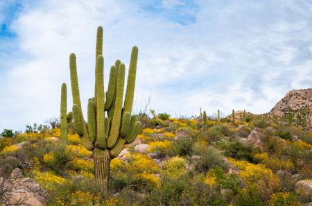
At mile 1.5 the trail curves into a side canyon and past a group of Saguaro cactus. These are the southernmost large Saguaro on the AZT and are great for a photo.
In 0.2 miles, go through a fence at the northern boundary of Cienega Creek Preserve. The trail climbs and then descends and winds through the low hills. An unusual castle, known as Agua Verde Castle, comes into view atop a hill to your right. Cross a gas line road at 2.5 miles and powerlines at mile 3.0.
The trail climbs to cross a fence line on the boundary of Colossal Cave Mountain Park and then heads for a saddle. It winds its way up the hill, reaching the high point at 4.2 miles. There is a view into Colossal Cave Mountain Park and La Posta Quemada Ranch below.
Continue through the saddle and switchback down the hill toward the ranch. The trail reaches a junction at 4.8 miles at a sign with a knife and fork and an arrow. Take the spur trail to the left (north) down the hill to across Aqua Verde canyon. At 5.0 miles, reach the creek bed and cross it to reach an Arizona Trail kiosk sign and a fence line at a picnic area.
Second Turnaround Spot
Go through the trees to the cowboy statue parking lot. Total mileage for the shuttle hike is 5.1 mi. If you didn’t leave a car here and are doing the 10.2-mile hike, return the way you came, making a right at the spur trail junction from the ranch.
For more information on the 800-mile Arizona National Scenic Trail, visit aztrail.org
If you go
Starting Trailhead: Gabe Zimmerman Davidson Canyon Memorial Trailhead
Ending Trailhead: La Posta Quemada Ranch
GPS coordinates Starting Trailhead: 32.0140388,-110.6476499
Arizona Trail Passage: Rincon Valley – Passage 8
Trailhead Elevation: 3,446 feet
Elevation gain/loss: 567/597 feet
Round-trip length: 5.1 miles for shuttle hike, 10.2 miles round-trip
Difficulty: Moderate
Why go: Cienega Creek riparian habitat, views of the Rincon Mountains
Nearest Gateway Communities: Vail (13 mi.)
Post-hike meal: Montgomery’s Grill and Saloon
Author
Sirena Dufault is the author of the forthcoming book, “Day Hikes on the Arizona National Scenic Trail,” which will be published by Wilderness Press. For more information, visit trailsinspire.com.