Trekking Arizona: the Arizona National Scenic Trail
From the desert to the mountains, the Arizona Trail touches five distinct biomes over 800 miles.
SHARE PAGE
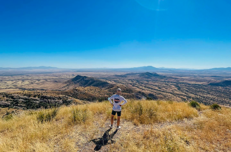
Arizona is a big state—the sixth-largest in the nation—and one way to get a sense of that expanse is to walk the length of it.
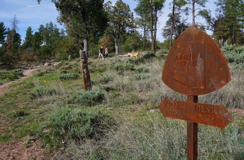
The Arizona National Scenic Trail is a lanky route traversing the entire state, stretching from Mexico to Utah for 800-plus miles and crossing isolated mountain ranges, rolling grasslands, sun-spanked desert, forested plateaus and a canyon called Grand.
Designated a National Scenic Trail in 2009, the pathway is popular with hikers, equestrians and mountain bikers.
The Arizona Trail is divided into 43 passages, and even those can be tackled in more bite-sized chunks. To sample some of the immense beauty of the Arizona Trail, here are a few passages, from south to north.
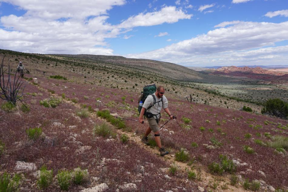
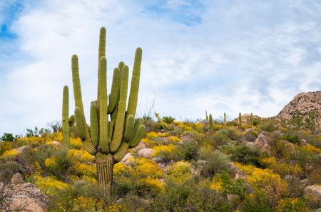
Passage 11: Santa Catalina Mountains (18.5 miles)
Hike from desert to cool mountain forests with a stop at a refreshing swimming hole as hike this route to the top of the Santa Catalina Mountains—which form the northern border of Tucson—and their rising ramparts of peaks and angled summits.
Starting at the Gordon Hirabayashi Trailhead, the trail first follows a dirt road before branching off past an old reservoir that's now mostly a marshy riparian area. (Don't worry, this isn't your swimming hole.)
The trail crosses Sycamore Canyon before making a steep descent into the Sabino Basin. You'll enjoy expansive views as you follow the east fork of Sabino Canyon, a woodsy cathedral guarded by cactus spines and rocky cliffs. Streams wind through canyon bottoms and around granite boulders, shielded by a slender forest of sycamore, cottonwood, willow, ash and walnut trees—and steep slopes above bristle with saguaro.
Past the junction with the Sabino Canyon Trail, continue uphill along the west fork to Hutch's Pool. With sheer rock sides and a small sandy beach, this is a popular swimming hole almost year-round.
Leave the pool behind—no easy task—and make the climb toward Romero Pass, steep at times but with level stretches intermixed. Turn onto Wilderness of Rocks Trail and again onto Marshall Gulch Trail, onward through pine forest to the trailhead. Bonus: You're just down the road from the mountain hamlet of Summerhaven, where you can treat yourself to a meal, a beverage and a cookie the size of a manhole cover.
Passage 19: Superstition Wilderness (29.4 miles)
This passage heads into the Superstition Wilderness, a fierce mountain range on the eastern edge of the Valley of the Sun that's rugged, untamed and drenched in legend. Blame it on the Dutchman's elusive gold.
Tales of the Lost Dutchman Mine began luring treasure hunters in the late 19th century with rumors of hidden gold and deathbed directions. Since then, several men have died under mysterious circumstances while seeking the mine and its treasure. Visitors today are more likely to encounter sunscreen-slathered hikers than grizzled prospectors
The trail first descends into Rogers Canyon, then angles northeast toward Reavis Saddle and on to historic Reavis Ranch, once owned by the colorful Elisha Reavis. The bearded recluse established a lonely homestead in the 1870s, growing vegetables that he occasionally sold in Phoenix and Florence. In 1896, his body was found on the trail, cause of death unknown. He was buried on the spot, and the Arizona Trail passes by the unmarked grave.
The ruins of the ranch are tucked away in a lovely valley with pine trees, a shady creek and a remarkable middle-of-nowhere apple orchard. After leaving the ranch, the trail climbs through Reavis Gap with good views along the way. You'll pass Walnut Spring and Cottonwood Spring.
The trail emerges from Cottonwood Canyon, and you're soon tracing the edge of mighty Roosevelt Lake past the marina and finally crossing the water on Roosevelt Lake Bridge.
Passage 31: Walnut Canyon (17.9 miles)
Starting from Marshall Lake, which is more marsh than a lake, keep an eye peeled for wildlife. This crucial wetland is a popular hangout for deer, elk, bald eagles, osprey and a slate of waterfowl. Enjoy an easy jaunt across Anderson Mesa, a gently sloping tableland with scattered timber framing views of the San Francisco Peaks.
The trail drops into Lower Walnut Canyon with wildflower-streaked meadows beneath cross-bedded sandstone cliffs. Shallow caves are gouged out along the base of the angled stone walls. Past the Sandys Canyon Trail junction, turn right and continue through Walnut Canyon.
A few hundred years ago, Walnut Canyon was a thriving population center for the Sinagua culture, and you can still see the remains of their prehistoric cliff dwellings secreted away in the natural contours of the gorge.
The trail climbs steeply out of Walnut Canyon at Fisher Point. From there it follows the rim, dipping in and out of a tributary gorge before reaching the trailhead near Interstate 40.
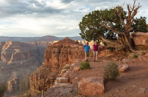
Passage 38: Grand Canyon Inner Gorge (21.8 miles)
It wouldn't count as an Arizona Trail if it didn't cross the "Big Ditch." This passage begins at the South Kaibab Trailhead and swoops down the canyon wall in a series of switchbacks. Just shy of a mile, it breaks free at Ooh Aah Point, thrusting out into the gorge with views breaking wide all around you.
The trail follows a spine of rock down to Cedar Ridge, then curves past O'Neill Butte and reaches the top of the redwall formation at a beautiful overlook called Skeleton Point. It zigzags down the cliffs to the Tonto Platform and makes a steep descent across the inner gorge.
The trail crosses the Colorado River at the Black Bridge. Head downstream to Bright Angel Creek and past the campground to Phantom Ranch, a great place to stop for cold lemonade. Follow the creek, and as you leave the ranch, the path becomes the North Kaibab Trail.
Climb through The Box, with exposed rock walls closing around you. The trail crisscrosses the creek on footbridges before reaching the short path to Ribbon Falls. This is a must-stop detour leading back to a picturesque grotto and a silver cascade that looks as if it were plucked from a tropical island.
From the falls, the trail continues along the creek to Cottonwood Camp. At last, it leaves the stream behind, passing the turnoff to Roaring Springs, a frothy geyser that provides all the drinking water for the Grand Canyon. You'll pass through a tunnel and climb the final switchbacks to the forested heights of the North Rim.
Explore the Grand Canyon by foot. From the most popular hike on the Bright Angel Trail to many more hikes that offer a scenic view.
About the Author
Roger Naylor
Roger Naylor is a travel writer who hates to travel. At least anywhere beyond his beloved Arizona. He specializes in lonely hiking trails, twisting back roads, diners with fresh burgers sizzling on the grill, small towns, ghost towns and pie. He has contributed to Arizona Highways, USA Today and Route 66 Magazine, and he is the author of Boots & Burgers: An Arizona Handbook for Hungry Hikers and Arizona Kicks on Route 66. He lives in Cottonwood, Arizona, and can be reached through his website, rogernaylor.com.